

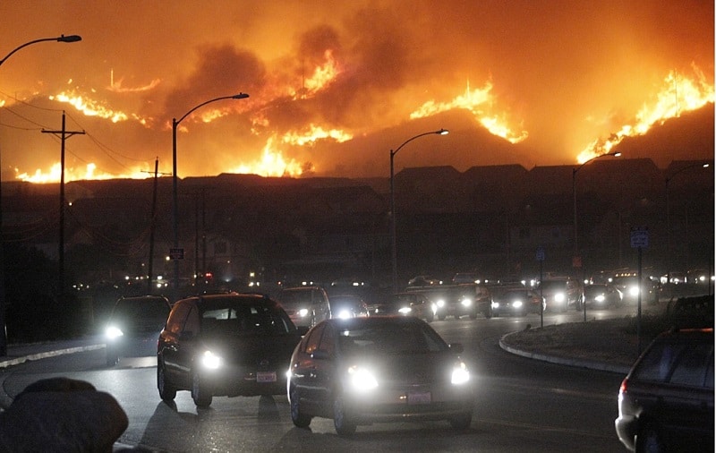
As a community we lived through the devastating fires of Waldo Canyon in 2012 and the Black Forest in 2013, but did you know that the last Wildfire Evacuation Plan was from 2010 or that you might live in a Wildland Urban Interface (WUI) area?
In May 2021, The Maverick Observer (TMO) was furnished a copy of a report named, “Screening Atlas District 1-9 … PPACG Travel Model Simulation Support” from Colorado Springs Wildfire Evacuation Planning, dated March 2010. As the report was studied and researched, one issue came into focus. The lack of clear-cut evacuation modeling to aid our community members in the event of a fire or other disaster.
To further complicate our evacuation modeling, in 2000 the Federal Government designated areas within the country as Wildland Urban Interface or WUI. As stated by the Colorado State Forest Service, “The wildland-urban interface, or WUI, is the area where structures and other human developments meet or intermingle with wildland vegetation.”
They further stated, “Uncontrolled wildland fire is particularly hazardous in the wildland-urban interface, areas where human development is close to, or within, natural terrain and flammable vegetation.”
Instead of heeding warnings about developing in these areas, such as the proposed development at 2424 Garden of the Gods Road, the city has denied the need for updated modeling and traffic studies within these potentially dangerous locations.
Roads Too Narrow and Too Few
The 2010 report clearly highlights our roads are too narrow and too few to accommodate both evacuating the public and getting first responders to the scene.
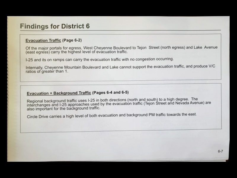
As an example, under findings for District 6, it states, “Internally, Cheyenne Mountain Boulevard and Lake [Avenue] cannot support the evacuation traffic and produce V/C ratios (V/C=volume to capacity ratio) of greater than 1.” The residents in southwest Colorado Springs may find themselves “sitting in a parking lot” rather than evacuating.
CORA Requests Will Bring Information to Light
Because of the research, TMO sought more information through CORA requests to the city. Below is the original CORA Request and the city’s response. Of particular concern in the city’s response is the denial of evacuation route maps for citizens to use during evacuation as they seek their Safe Zones.
CORA Request – 8/12/2021 – This CORA Request is for the City of Colorado Springs Office of Emergency Management (because it’s a 2017 document) and the Communications Center. The Public Egress page 19 in the WUI Fire Evacuation Appendix A to the Colorado Springs Emergency Operations Plan dated 9/5/17, indicates “The neighborhoods within the Wildland Urban Interface (WUI) have been modeled to determine:
- Amount of time needed to evacuate
- Evacuation routes … Maps have been created showing the evacuation routes and traffic control points.
- Locations of traffic control requiring traffic control personnel or devices to direct evacuation traffic and to restrict re-entry into the evacuation zone.
- The map breakdown for each neighborhood located within the WUI and show traffic evacuation routes, control points, safety locations, optimal use of two-way or all one-way traffic.
- Copies of the Fire Evacuation Traffic Control Plan with the maps described above will be available in the CSPD Command Post, Falcon and Gold Hill Divisions, Communication Center, and the Emergency Operations Center.
- An explanation of the traffic modeling is located in Section 11, pages 47-52.
Please provide copies of all the information listed above. I am specifically interested in the models and Evacuation Routes. Also, Section 11, pages 47-52 was not included in Appendix so I would like copies of those pages.
CORA Response – Section 11, pages 47-52 in the WUI plan dated 9/5/17 on the Public Egress page is a misprint. There is no Section 11 in that version. The plan dated 6/01/12 included a Section 11, pages 47-52. However, the information being requested is in both versions of the plan. The WUI plan (9/5/17) includes the evacuation modeling methodology in Section 10, pages 37-42. The maps, evac times, neighborhood evac routes, etc. are a part of the Colorado Springs Wildfire Evacuation Plan Screening Atlas. There are two, the Neighborhood Analysis and the Traffic study for Districts 1-9. However, the City denies your request for evacuation routes, times, and specific maps due to the security concerns and pursuant to Colorado Revised Statutes § 24-72-204 (2)(a)(VIII)(A). The city is providing the evacuation zones map book as it may also respond to your request. Please follow the link below to download your responsive record. https://gov.publicstuff.com/r/get/5d465aef (Aug 13, 2021, 1:24 PM MDT by CORA Team.)
What About Our Safety?
This CORA response is unacceptable to the TMO and should be to all the citizens in this community.
The mayor and city council should put our safety and the safety of our families as a number one priority, instead of relegating it to a 2010 report and outdated traffic studies.
Evacuation Signs in Buildings, But Not for Our Neighborhoods
The International Fire Code requires evacuation information and specific directions/signs in every building so individuals know how to evacuate in any event; however, if there is a wildfire, flood, or another hazard, the city is not providing adequate information to its citizens to prepare, plan and implement an efficient evacuation.
Intuitively, shouldn’t travel routes, safe zones, and other important information be available to citizens for successful evacuation planning and preparedness?
Demand Up-to-Date Modeling and Planning
We have the information from the 2010 report, but due to significant changes in demographics and infill and proposed development, we believe it is prudent for the city to complete a new study for the WUI. Since the 2010 report included specific and detailed evacuation maps as well as evacuation time criteria for all nine districts, it is essential for the new study to include these items.
The city has an opportunity to use the Fast Local Emergency Evacuation Times or FLEET to model evacuation scenarios and should take advantage of this software. We should not accept “Emergency conditions are not modeled, but managed,” as stated by Travis Easton, Colorado Springs Director/City Engineer at a recent city council meeting.
You Can Make a Difference
We demand our city officials provide us with updated information so that we can safely evacuate. Join us in corresponding with our mayor, city councilmembers, and El Paso County commissioners by clicking the link below and making your voice heard.
We can make a difference if we unite in this dire situation. Don’t let the city ignore our pleas. Use the Email button below to send a pre-formatted email to your representatives.

Email Your Elected Officials
Use the link below to easily engage with your elected officials. You can let them know how you feel on the subject addressed in this article. We made it easy by formatting the email to include the script and important information.
NOTE: Before you hit send on the email, be sure to change your name. It is important that they know that it is coming from you! If you need help, please contact us at info@themaverickobserver.com. Thank you!
Click Here to Send Pre-formatted Email


[…] out these articles on wildfire evacuation and clearance time modeling for more […]