

Bill Requiring Wildfire Evacuation and Clearance Time Modeling Gets Reintroduced as a Study Bill
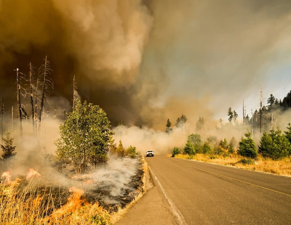
In recent years, the state of Colorado and other parts of the country have experienced the loss of lives and structures due to people not being able to get evacuated quickly enough. During the Waldo Canyon Fire, two people died because they were not able to leave before the flames engulfed their homes.
Over 20 years ago when the devastating Hayman Fire burned thousands of acres, the main means of evacuating people were law enforcement driving through neighborhoods telling people to leave over a loudspeaker. With better technology, there are other methods used for evacuations like alerting media sources and issuing reverse 911 alerts.
However, it has been proven time and time again that evacuation methods are not 100 percent effective. Some people in the threatened areas do not get the alerts, and sometimes the alerts do not get sent out to everyone in the affected areas.
One state lawmaker proposed a bill to implement evacuation and clearance time modeling in high-risk areas, but based on the comments from officials, Snyder has decided to pull the bill from the state legislature. Instead, he plans to rewrite the bill and then submit it as a study bill to be reviewed by the state’s office of emergency management before he brings it back to the legislatures hopefully before the end of the year.
What is Wildfire Evacuation and Clearance Time Modeling?
Many say that the use of evacuation and clearance time modeling can become a valuable tool to aid authorities in evacuating residents. In California, officials use traffic modeling to estimate the amount of time it could take for people to leave a given neighborhood.
In Colorado, State Representative Marc Snyder who represents El Paso and Teller Counties recently proposed a bill that would require evacuation and clearance time modeling to be conducted in wildfire-prone areas. According to Snyder, evacuation modeling can be a valuable tool for pre-evacuation plans and a good way to inform people of how long it could take them to evacuate.
“My idea is that we could have a website where people could type in their address and it tells them right away, there are five ways out from where you live and there would be times associated with it. It would give you the estimated time that it would take you to evacuate safely,” Snyder said. “My hope was to create this evacuation modeling website not really as a tool to use in real-time during evacuations, because I would never do anything to up hinge or somehow diminish an incident commander’s absolute authority in real time to make life or death decisions. So really it has become more of a pre-evacuation tool. So if people went on the website and found out that the way they needed to evacuate would take three or four hours in a mass evacuation scenario, I was hoping that that would be an incentive for them to say, ‘You know what I’m not going to wait until I get a call, I am going to pack up and get my family, my pets, and my valuables out of here now.’ If I can reduce the number of people by 30 or 40 percent it could only help an evacuation crisis like that.”
What Would the Bill Require if Passed?
If House Bill 23-1075, “Wildfire Evacuation And Clearance Time Modeling” or a similar bill passes, it would require that evacuation time modeling gets conducted in certain “wildfire risk” areas. The first section of the proposed bill directs the Office of Emergency Management to provide resources and technical assistance to eligible entities “to conduct evacuation and clearance time modeling and to publish the results to an interactive website.”
“An eligible entity includes a fire department, governing body of a political subdivision, local or inter-jurisdictional emergency management agency, or homeowners’ association that is located in or provides services to a wildfire risk area,” the proposed bill states. “The office is required to conduct an outreach and education campaign to advise eligible agencies of the program.” The bill then requires that on or after July 1, 2026, each emergency management agency that has jurisdiction in a wildfire risk area “must perform evacuation and clearance time modeling and include the information in the emergency management plan for its area.”
The second section of the bill requires starting on Jan. 1, 2024, that developers perform evacuation and clearance time modeling for proposed developments and submit it to the local government. A local government would not be able to approve a development unless it has approved the evacuation and clearance time modeling plan that will be part of the application.
Proponents Say Evacuation Time Modeling Can Help Save Lives
Rep. Snyder said that after he experienced the Waldo Canyon Fire as the mayor of Manitou Springs, helping people evacuate promptly in times of need became important to him. He also gave examples of the recent Marshall Fire in northern Colorado and the Paradise Fire in California, where people died on the roads evacuating from their homes.
“It was something that really caught my attention,” Snyder said of the Paradise Fire tragedy. “We saw the Marshall Fire where reverse 911, as far as I can tell after talking to a lot of various officials, they put reverse 911 at 70 percent efficacy. Because people don’t keep up and maintain their current phone number on the registry.”
He said that California is the only other state that has implemented some type of evacuation time modeling system, but the state is still working out some kinks with it.
“I understand the rollout hasn’t been perfect, they are having some of the same troubles we are having,” Snyder explained. “The last thing you want to do is put something on a website that indicates to people, this is a preferred way to evacuate when the fire can change characteristics and can change direction. Then you could actually be sending people into a bad situation.”
Some Officials are Concerned About the Bill
When the topic of evacuation and clearance time modeling gets brought up, leaders of emergency management departments fear that the modeling website would keep people from listening to incident commanders when they give safe ways to evacuate. Snyder said that he understands concerns from fire officials that people will choose to go the way the modeling says instead of what the incident commanders tell them.
“They are hesitant to put that out publicly facing,” Snyder said. “The conditions on the ground can change in a hurry and if they put something out that tells people that these are the main artery roads and then the winds changes and those artery roads become a threat, people will still use that older information.”
Check out these articles on wildfire evacuation and clearance time modeling for more information.


